


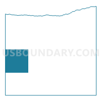
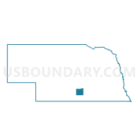
Mirage Precinct, Kearney County, Nebraska
About
Outline

Summary
| Unique Area Identifier | 613304 |
| Name | Mirage Precinct |
| County | Kearney County |
| State | Nebraska |
| Area (square miles) | 36.02 |
| Land Area (square miles) | 36.02 |
| Water Area (square miles) | 0.00 |
| % of Land Area | 100.00 |
| % of Water Area | 0.00 |
| Latitude of the Internal Point | 40.48134170 |
| Longtitude of the Internal Point | -99.12259820 |
Maps

Graphs
Select a template below for downloading or customizing gragh for Mirage Precinct, Kearney County, Nebraska


Neighbors
Neighoring Voting District (by Name) Neighboring Voting District on the Map
- Anderson-Cottonwood Precinct, Phelps County, NE
- Blaine Precinct, Kearney County, NE
- Divide and Lake Precinct, Phelps County, NE
- Hayes/Logan/Sherman Precinct, Kearney County, NE
- Oneida Precinct, Kearney County, NE
Top 10 Neighboring County Subdivision (by Population) Neighboring County Subdivision on the Map
- Hayes township, Kearney County, NE (1,481)
- Mirage township, Kearney County, NE (890)
- Blaine township, Kearney County, NE (612)
- Oneida township, Kearney County, NE (482)
- Divide township, Phelps County, NE (344)
- Logan township, Kearney County, NE (160)
- Anderson township, Phelps County, NE (139)
- Lake township, Phelps County, NE (132)
- Sherman township, Kearney County, NE (70)
Top 10 Neighboring Place (by Population) Neighboring Place on the Map
Top 10 Neighboring Unified School District (by Population) Neighboring Unified School District on the Map
- Minden Public Schools, NE (4,397)
- Wilcox-Hildreth Public Schools, NE (1,470)
- Axtell Community Schools, NE (1,358)